
Why exactly are we starting right here?
…just trust us, you’ll see.
by Sean Meehan
One of the most frequently asked questions on our trips is: How did you guys find these runs?!
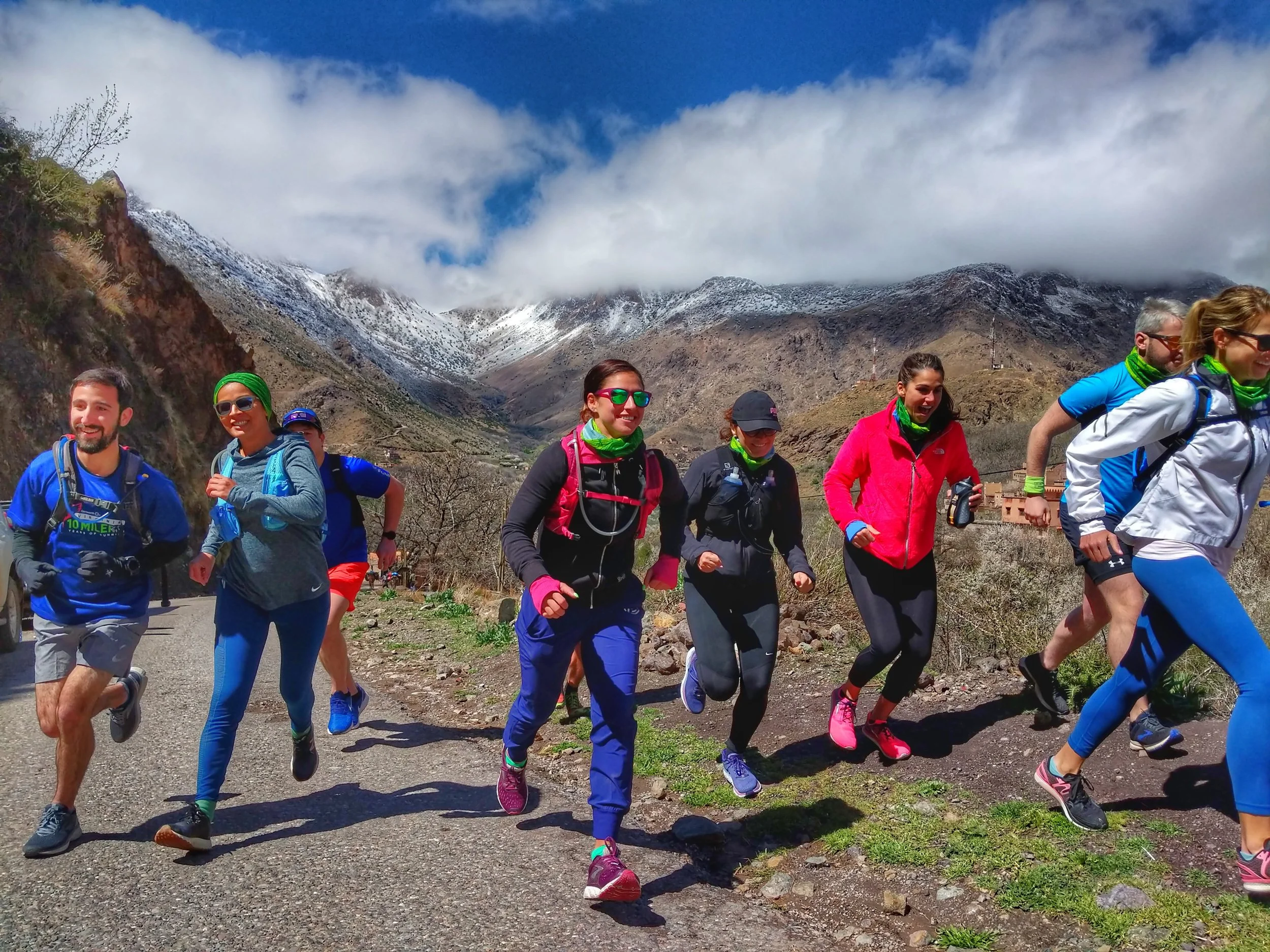
We get it. There are some highly arbitrary start lines. We dump everyone out of a vehicle in some nondescript roadside location and starting proclaiming about how, over the next few miles, everyone will see waterfalls, or canyons, or ocean views, or lakes, or mountain passes, or whatever the case may be. Often there are a few highly dubious expressions looking back at us. But (trust us!) it all works out in the end and every run is unique in its own way.

Long walks with mules also come into the equation more often than you’d think!
Finding those runs though, can be a pretty interesting experience. After someone has thrown a dart at the world map on the wall at Rogue HQ and decided a new destination, there follows a process of trawling online maps, hiking trail websites, reading about tourist attractions, much panning around on google earth. Then once on the ground for scouting, there is a lot of driving, some running down dead ends, or the wrong trail, or on to someone’s private property, some more driving, some interrogation of local experts, more driving, find new trail maps, mess around on google earth again, drive a bit more, run around a bit more. And then, maybe 25% of the time, we have a run that is a keeper.
Even in countries we have visited many times there are always new runs to uncover. This fall will see a brand new Morocco itinerary with the inaugural Atlas Mountains trip. Morocco is where is all began for us 7 years ago, and now, many trips later, we are much the wiser when it comes to haggling for a carpet, or having a dirham coin handy for those crucial over-hydrated toilet visits, or knowing just how much sugar to add for that perfect glass of mint tea (hint: add more). Cultural learnings acquired there is still much to explore even after umpteen visits to a country. In fact, only once you are truly comfortable with a place, fully in sync with how things work, and having explored a country’s tourism highlights are you then equipped to go next level and explore all those mysterious corners of the map. Turn down the road you’ve driven past a dozen times, cross over the mountain pass you’ve gazed at from your riad window evening after evening, and uncover the next hidden gem of a run.

Sooo… coffee time?
Many run ideas die almost as soon as we think of them. They are born full of hope and then, fueled by coffee and chocolate, we explore (usually with Hamid on his “days off’... sorry Hamid), only to discover that the run won’t work: too much traffic, too confusing to navigate, too many hills, not enough hills, no picnic spot, too hot, too cold, too much road, not enough road, etc etc. Many hours later, usually in need of more coffee and chocolate, he’ll still be smiling, entirely unworried by our total failure to find a run.

“Just drop me off here. No need to wait.”
Of course, there are success stories too. A few years back Gabe wrangled a taxi driver from Taghazout into driving out into the mountains to a totally unknown destination. No place name. No nearby attraction. Just a road intersection Gabe had guessed off a map. After much cajoling and reassuring en route (“extra dirhams sir, yes, yes..”), Gabe finally and abruptly called a halt to their tour of the quiet mountains. He hopped out of the back seat with a running pack on and said goodbye, disappearing up a rocky track into the trees. Oh, to know the thoughts of that taxi driver as he, incredulous at what he had just witnessed, u-turned and headed back to civilisation (anyone who has ran the Paradise Valley run on our Mountains & Coast trip will know the lonely stretch of road we are talking about).

If you run out of candy bars, there is at least one source of scouting run fuel that can always be found in these mountains!
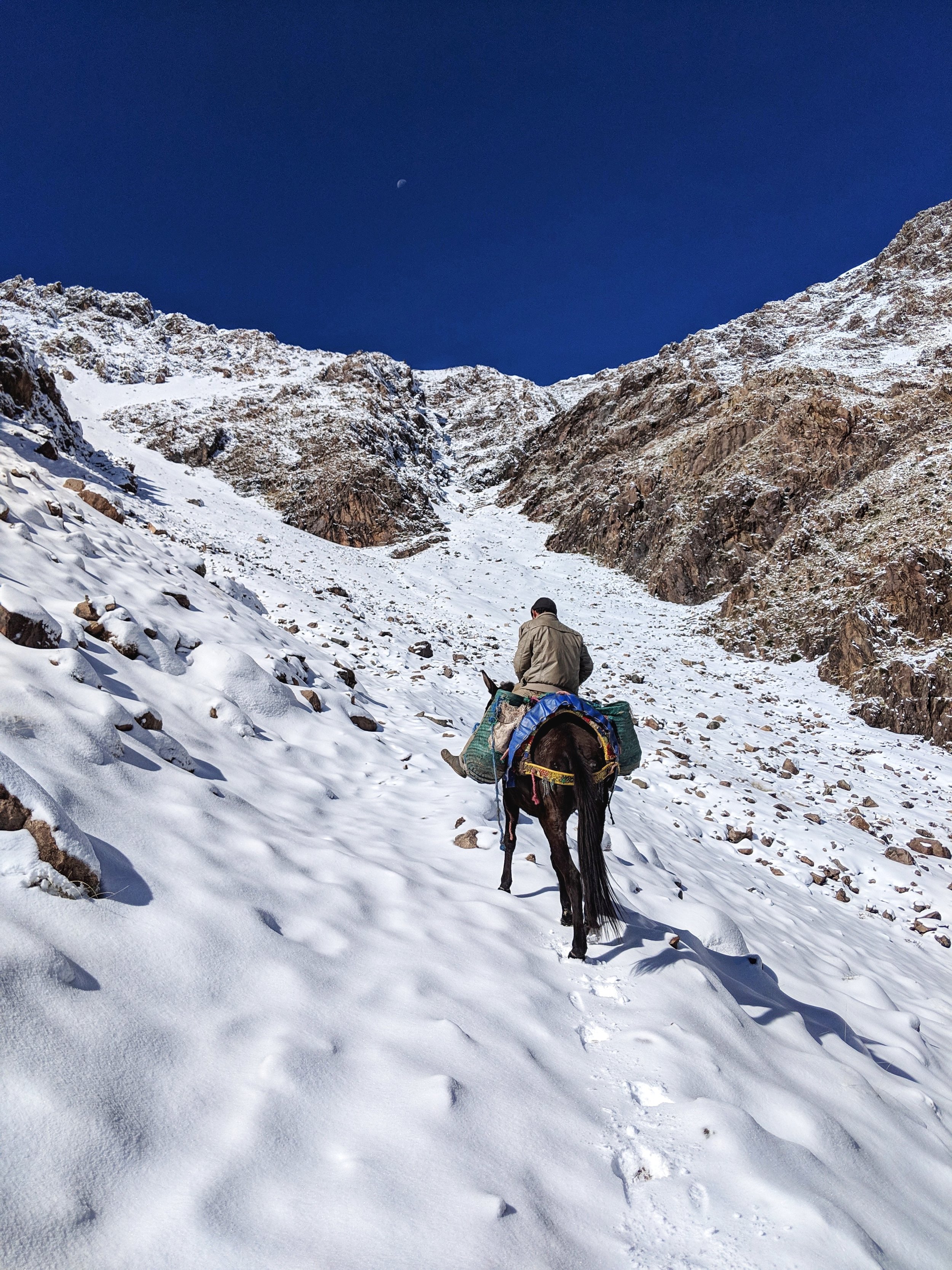
Last October I (Sean here, hello!) got Hamid to drop me off where the pavement ends at the top of the Ourika Valley. I had a couple of litres of water, many Snickers bars, some dirham, a toothbrush and toothpaste, a rain jacket, an an extra shirt. Hamid was highly skeptical as my destination was Tizi Tacheddirt, a pass at over 3000m (almost 10000 ft), many miles away on the way to the Imlil valley. That first day I cantered up into the mountains through ever smaller and more remote villages, before starting the climb to the pass in earnest. I was 3 Snickers bars in (about 5 hours) and it was late afternoon and starting to snow. Higher I went, harder it snowed, so eventually I backtracked to the last village. Much sign language and bad French later I had a bed for the night and a hot tagine for the princely sum of $6 total.
When in doubt, listen to the locals. And follow the mule.
The next morning, after a cold night of snow, my host, with much gesticulation and equally bad French, was dead set against my intentions of Tizi Tacheddirt. “Neige comme ça” he indicated his hand around the middle of his chest (translation - snow like this). Mmm I thought. Neige comme ça is it. I had no crampons or proper cold weather gear. “Oukaimeden?” I asked him, pointing vaguely in a different direction up the valley. “Oui, oui!” My host was visibly relieved. “Neige comme ça” he indicated his hand to his ankles with visible glee. I bade him farewell and 2 Snickers bars later I arrived in another small village and somehow acquired a mule driver despite my protests against it. He was on his way to Oukaimeden he said. Noticeably, in this village my basic French and Arabic was getting only bemused faces. I was firmly in Berber-only territory, probably Tamazight, the mountain dialect. The small children in the village crowded around the strange sweaty Irishman with the funny little backpack. They one by one took my hand and pressed it against their lips. I later learned this is a sign of respect to elders, a very old Berber tradition. And so, with this most formal of farewells, we set off over a mountain pass about which I had no idea.

Another Snickers bar later and with version two of ‘neige comme ça,’ (ankle deep) we crested over the mountains at about 10,000 feet had the most incredible views of the High Atlas. We descended into a remote valley, through some herder huts, and then, almost perversely, rounded a corner and we were smack bang in the middle of Oukaimeden, Morocco’s only ski resort. I stumbled into town, quite unwashed, alongside my mule driver, and headed in search of coffee. Rich Moroccans, clad in fancy ski gear, clomped around in ski boots as vendors roamed in their midst trying to sell fossils and geodes. I had, totally unintentionally, linked two great valleys of the High Atlas. These two valleys (minus the sketchy snow covered route I took) now form the basis of our new trip! They sidestep the mass tourism attractions in the area to uncover the wonderful traditional life that exists, untouched, just around the corner from these sights.

And an hour later…
Post coffee it was a helter-skelter taxi ride (I believe no less than 7 people were inside the 1960s era Mercedes) down from the ski resort and then I was back in the Ourika Valley again. Less than an hour later I was walking across Jemaa el-Fnaa, the main plaza in Marrakech, and got back to our riad to rejoin Katie and Gabe just before the running group arrived. This time I had uncovered a true gem: astonishing sections of the mountains, with traditional life intact and frozen in time, were right there, within a couple of hours of Marrakech - and with that, The Atlas Mountains trip was born!
Don’t worry, the runs that made the final cut are far more, um, runnable.
*Disclaimer - if you attempt to run one of the sketchily mentioned “routes” in this article without a Rogue Expeditions guide you are entirely responsible for your own fate :)